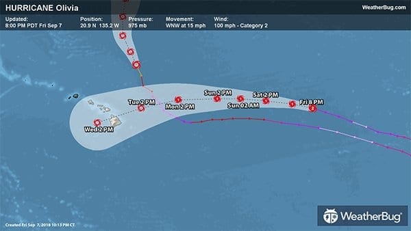
Hurricane Olivia could become a threat to Hawaii early next week. While it should weaken to a tropical storm by then, heavy rain, gusty winds, and rough surf are all possible.
While residents along the Atlantic Coast are keeping a close eye on the progress of Hurricane Florence, Hawaiians are once again watching the tropics for themselves. Hurricane Olivia could be headed for the island chain by the middle of next week.
As of 8 p.m. PDT (5 p.m. HST), Hurricane Olivia was located near 20.9 N, 135.2 W, or about 1460 miles east of Honolulu, Hawaii. With maximum sustained winds of 100 mph, Olivia is now a Category 2 hurricane on the Saffir-Simpson Hurricane Wind Scale. Olivia is located west-northwestward at 15 mph, with a minimum central pressure of 975 mb or 28.80 inches of mercury.
Olivia is moving over relatively cool water, causing the storm to weaken. This trend is likely to continue for the next several days, with Olivia dropping to a Category 1 hurricane over the weekend, and possibly to a tropical storm by Monday or Tuesday.
The bad news is that Olivia will continue tracking west to west-southwest around a large area of high pressure located across the northern Pacific Ocean. This will put the storm on a bee-line for the Hawaiian Islands except for the Island of Kauai. Some forecasters predict the eye of the storm could pass between Maui and Oahu and over Molokai and Lanai, putting a large area of the State of Hawaii at risk.
Heavy rainfall, on the order of 6-12 inches, would be possible if Olivia makes a direct landfall on Hawaii, even in a weakened form. This would cause flooding and mudslides. Wind gusts of 40-60 mph are also possible.
For their own security visitors and locals should stay on top of the news and follow instructions by authorities to avoid problems.
WHAT TO TAKE AWAY FROM THIS ARTICLE:
- Some forecasters predict the eye of the storm could pass between Maui and Oahu and over Molokai and Lanai, putting a large area of the State of Hawaii at risk.
- This trend is likely to continue for the next several days, with Olivia dropping to a Category 1 hurricane over the weekend, and possibly to a tropical storm by Monday or Tuesday.
- Heavy rainfall, on the order of 6-12 inches, would be possible if Olivia makes a direct landfall on Hawaii, even in a weakened form.


